Link here Revit: Collecting packaging
Do you want to get an advance peek at possible new features, or even influence future releases of the Revit application suite?
Revit Research Recruitment Survey
Here is a challenge for you API and programming wizards out there: make a tool that monitors the performance and productivity of a Revit user.
What am I talking about? Mainly, I want to know how I can improve my productivity. I can see two big ways:
- Ensure I am using keyboard shortcuts where possible
- Avoid triggering commands unnecessarily, and thus having to abort them and retry
Here is the kind of output I would be looking for:
start sample data
REVIT SESSION Productivity Analysis
Number of commands initiated: 2493
Top 50 commands initiated:
Zoom Extents
Trim
Scale
Copy
…etc…
% of Top 50 initiated using keyboard shortcut:
43%
List of Top 50 commands initiated WITHOUT keyboard shortcut:
Align
…etc…
Total number of commands initiated and then aborted without doing anything:
176
List of commands most commonly aborted:
Cut Geometry
…etc…
end sample data
You get the idea? Such a utility could show me which tools I should add to my arsenal of keyboard shortcuts. It would also show me which commands I am not using correctly or triggering unnecessarily.
How could this tool be developed? I see two main ways:
- Create a tool to parse and analyse the output of the journal file for the session.
- Create an API tool that monitors and logs the necessary data, then displays it
Who is going to rise to the challenge?
To quote one of my favourite shows:
And if ever a challenger wins over the Iron Chef, he or she will gain the people’s ovation and fame forever!
Go here for heaps of Revit Tutorials…essentially it is an aggregator for tutorials found on the Internet.
“Greetings from the Revit® Product Team,
Please click on the link below to take the annual survey on your Satisfaction with the Revit® Architecture product from Autodesk®.
This survey should take about 15-20 minutes of your time.
The survey will be open for approximately 2 weeks.
Deadlines. CAD-method: throw warm bodies at it. Complex #Revit projects however, prove the adage “nine women can’t make a baby in one month”
Twitter / NMcClure: Deadlines. CAD-method: thr …
quote “I have been asked by a few customers if Revit will cache textures in graphics RAM just like a game system might? … I am happy to say the answer is yes – Revit will fully use this RAM and the graphics team is continually looking to make improvements in memory management.”
From Erik at Inside the Factory: Revit and your Graphics Card
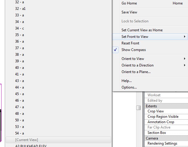
To change which orientation that the Revit ViewCube thinks is the ‘Front’ for a specific view, check out the video below, or scroll down for the quick step-by-step.
- Orient the view to the orientation you would like to be the Front. This will have to be a ‘horizontal’ view.
- Right-click on ViewCube, go to Set Front to View
- Click on [Current View].
Note: Press the letter ‘A’ on your keyboard if views with numbers in front are hiding the [Current View] option – it is quicker than scrolling!
My previous Blog post about Orient to a Plane
- Typos are made during activation
- The serial number you are attempting to use does not match the product
- The serial number you are attempting to use is truly not valid anymore
- The contact information you are using does not match what is already associated with the Serial Number when the product was registered