A few tips from Adam Sheather:

  • Change your (Recap) temporary folder locations for conversion 
  • If you need to move cloud file between offices, convert them first to lower transfer times.
  • Ask for ptg files for readability
  • Using Remote Desktop services may be an issue if your card doesn’t support at least OpenGL 3.1 for remote services.

From:
Stuff and BIMs: Point Cloud beginer tips

You may also be interested in my detailed post at:
What Revit Wants: Creating Revit Geometry from Point Clouds (Points to BIM workflows)

From viewing the video, it looks like you just:

  1. Take some pictures with your drone and GoPro
  2. Upload to Recap 360 and make sure you get an RCS output
  3. Link it into Revit and do your conceptual modelling
  4. Visualize the model using the site context from the linked RCS point cloud

Easy!

Here’s the video:

Heads-up https://twitter.com/Alex_BIM_AJP/status/479897809634988033

Readme:
http://download.autodesk.com/SWDLDDLM/Updates/ReCap/Autodesk_ReCap_2015_Hotfix1.html

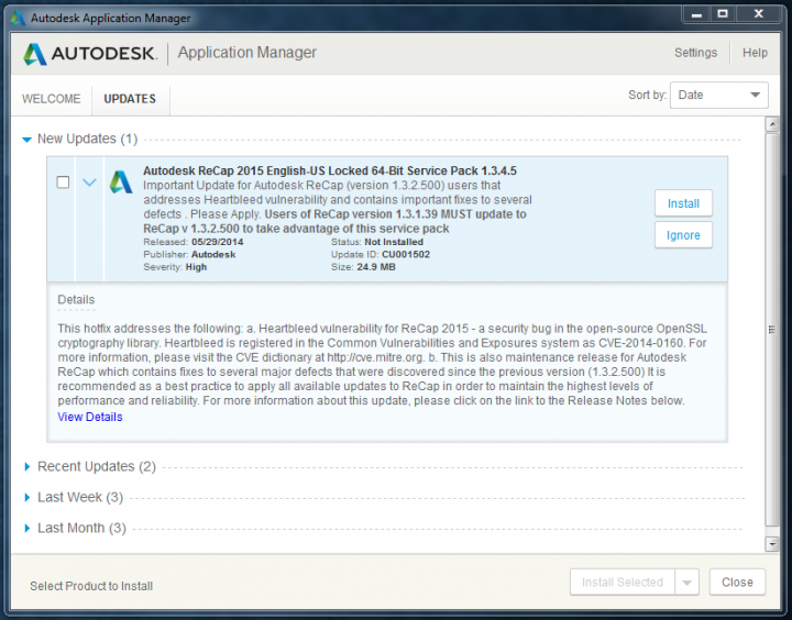
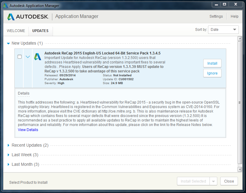
1.    This hotfix addresses Heartbleed vulnerability – a security bug in the open-source OpenSSL cryptography library. Heartbleed is registered in the Common Vulnerabilities and Exposures system as CVE-2014-0160. For more information, please visit the CVE dictionary at http://cve.mitre.org.
2.    This hotfix fixes the bug in ReCap that project file might be corrupted or deleted when computer went to sleep or shut down during scan importing.
3.    This hotfix fixes the bug in ReCap that PTG with only intensity are imported as all-black.
4.    This hotfix adds the support for US Survey unit in ReCap.
5.    This hotfix fixes the bug in ReCap that project cannot load on A360 if map images do not exist in Temporary Cache when publishing.
6.    This hotfix fixes the memory allocation error in ReCap during registration.
7.    This hotfix fixes the bug in ReCap that export might fail under certain conditions.
8.    This hotfix fixes the bug in ReCap that region is not displayed properly when reopened after deletion of points.
9.    This hotfix fixes the bug in ReCap that project save as function is not copying all support files to destination folder when merging several projects.

To get a Free trial of Autodesk ReCap Pro click on the following link: ReCap Free Trial

You can use Autodesk ReCap 360 now for free if you have a Autodesk 360 account. If you don’t have an account, you can sign up for free by clicking on the following link: Autodesk ReCap 360

Read more:
http://www.cadlinecommunity.co.uk/Blogs/Blog.aspx?ScoId=f542a2ef-8a1f-4223-af91-6d52aea299b0

Autodesk offers several different browser-based user interfaces for different reality capture scenarios.

They all use the same underlying ReCap REST API.

You need a special developer key to make use of the API. To obtain one, please contact ADN and ask to become a pilot partner.

ReCap is built on Amazon web services, using queues to manage jobs.

current pilot partners and their work, some of which was also being shown in the AU exhibition:
  • SoundFit custom fit ear gear, creating a precise model of the inner space within the ear for prosthetics, a fully automated complete custom application.
  • Kubit, dealing with AutoCAD applications for real-world as-built capturing.
  • Skycatch, providing a low cost, highly flexible, intelligent & scalable aerial robotics platform.
Tilo Pfliegner of Kubit demonstrated easy integration of calibrated photos, point clouds and ReCap models into AutoCAD.
Point clouds are sometimes too imprecise for modelling needs. Using photos directly instead is better, because they are often more precise, and the photo quality is often better than the generated point cloud.
Read more / via:

Had a pretty persistent error which wouldn’t allow Recap to install SP1.  In hindsight, it was probably related to the error at this post:
http://upandready.typepad.com/up_and_ready/2013/07/autodesk-recap-10-error-installing-sp-1.html

Basically, the program thinks it needs an update when really it doesn’t, and you might have to do a registry edit to fix it.

If you want to know more about MSP files generally:
http://msiworld.blogspot.com.au/2008/09/installation-of-msp-file-in-silent-mode.html

http://www.windowswiki.info/2009/02/19/how-to-extract-msumspmsiexe-files-from-the-command-line/

http://www.msigeek.com/647/command-line-switches-for-msi-and-msp-installations

Also – UniExtract can be used to extract MSP files.

Links:
UniExtract Installer (5.3 MB) – This is the recommended download. The installer will automatically install the application and optionally integrate with the Windows Explorer context menu. This package does not contain source code.

UniExtract Binary Archive (4.95 MB) – This archive contains the binaries. Download this if you want portable version or just prefer not to use the installer.

EDIT:
You can also use the command line.  See below for workflow related to Autodesk 360 update 3:

  1. Download Autodesk 360 Update 3:
    http://usa.autodesk.com/getdoc/id=DL21520422
  2. Open a Windows command line:
    Click Windows Start menu  > Search > type cmd and press Enter.
  3. Change the working directory to the folder where you downloaded Autodesk 360 Update 3.
    Example: cd c:a360u3
  4. Run the following command to extract the msp file:
    c:a360u3> Autodesk360_x64_Release_update3.exe /e a360u3.msp
  5. Install Update 3:
    c:a360u3> msiexec /update a360u3.msp /passive /norestart

The scenario: you receive raw point cloud data, and want to process it in Recap (part of 2014 suite), export to PCG, and import back into Revit 2013.

Or: you request a PCG from a surveyor for Revit 2013, and they give you a “newer” PCG from Recap that will not import.

The error received in Revit 2013 is:
“Unable to create a Point Cloud instance.  The file may be an incompatible format or corrupt.”

However, if you index the same raw point cloud data using Revit 2013 built-in indexing, the resulting PCG will work fine.

It would seem that there is some difference between the built-in Revit 2013 indexing of PCG point clouds, and the PCG point cloud exporter in Recap.

Workaround:

  1. Process the raw data in Recap (requires indexing time)
  2. Export to PTS file
  3. Import the PTS into Revit 2013 (requires indexing time — again)

The current version of Recap Pro runs on Windows 7 and 8 (download link).

However, for the time being you can still download Recap version 1.0 from this link:
http://labs-download.autodesk.com/us/labs/trials/worldwide/ReCap1.0.exe
and the service pack for x64 at:
http://updatesdl.autodesk.com/updates/files/autodeskrecap_sp1_for1.0.43.27_x64.msp

If you ever need to run Recap on XP, it might be handy to have this installer in your toolkit…

Navisworks may have issues importing PCG point cloud files.  For example, if you try to append a PCG directly to Navisworks Manage 2013, it will say “No plugin exists that will open pointfile.pcg”.

If you try to export a view from Revit 2013 to Navisworks and it contains a linked point cloud file, the point file will not be converted even if the “Convert linked files” option is ticked in Navisworks settings.

Here are some workarounds:

Some have recommended importing the PCG into AutoCAD, and export an NWC from there:
Revit OpEd: Point Cloud Data into Navisworks
Point cloud import – Autodesk Discussion Groups

You can also:

  • Import PCG to AutoCAD, then append the DWG to Navisworks
  • get PTS from Cyclone, or even TXT, and then append it directly to Navisworks
As per:

Point Cloud files imported into Navisworks & Revit from Cyclone, .pts vs .ptx. | LinkedIn

Depending on the size of the original point cloud file, it will take some time for Navis to make the necessary indexed NWC file (like half a day maybe).

Obviously, if you are living in 2014-Suite-Land, you can also just use Recap to import the PCG and export as a supported file format for Navisworks.

A 2008 PDF that describes the point cloud types Navis supported:
http://www.sparpointgroup.com/uploadedFiles/News/PDF/peterquinn.pdf